Showing posts with label Province of Indonesia. Show all posts

Friday, 27 September 2013

Riau, a province of Indonesia

Riau

Riau
Riau is a province of Indonesia. It is located in the central eastern coast of Sumatra along the Strait of Malacca. Until 2004 the province included the offshore Riau Islands, a large group of small islands located east of Sumatra Island and south of Singapore, before these islands were split off as Riau Islands Province in July 2004. The provincial capital of Riau Province and its largest city is Pekanbaru. Other major cities include Dumai, Selat Panjang, Bagansiapiapi, Bengkalis, Bangkinang, Rengat and Siak Sri Indrapura.
RiauRiau is currently one of the richest provinces in Indonesia and is rich with natural resources, particularly petroleum, natural gas, rubber, palm oil and fiber plantations. However extensive logging has led to a massive decline in forest cover from 78% in 1982 to only 33% in 2005. This has been further reduced an average of 160,000 hectares per year on average, leaving 22%, or 2.45 million hectares left as of 2009. Deforestation for palm oil and paper has led to not only perennial serious haze over the province, but in Kuala Lumpur, Malaysia, intensifying flooding and landslides. Kuala Lumpur and surrounds has been sent into "unhealthy" air quality levels again in mid-2012 from Indonesian haze originating in Riau.
Since the 1970s, much of Indonesia has experienced declining population growth rates. Riau has been a significant exception, with increasing rates every decade since 1970 to a 4.35 percent annual rise for the 1990s. The provincial population is 5,543,031.
Riau Province is home to various dialects of the Malay and Chinese language. The dominant language used by the Malay population is Malay. The Chinese population speak a variety of Chinese dialects, the most common being Min Nan, originating from the southern part of Fujian province in the south-eastern part of China.
The dialect of Malay spoken in Riau Province is considered by linguists to have one of the least complex grammars among the languages of the world, apart from creoles, possessing neither noun declensions, temporal distinctions, subject/object distinctions, nor singular/plural distinction. For example, the phrase Ayam makan can mean, in context, anything from 'the chicken is eating', to 'I ate some chicken', 'the chicken that is eating' and 'when we were eating chicken'. The traditional script in Riau is Jawi (locally known in Indonesia as "Arab-Melayu"), an Arabic-based writing in the Malay language. A possible reason for this is that Riau Malay has been used as a lingua franca for communication between different people in this area during its history, and extensive foreign-language speaker use of this kind tends to simplify the grammar of a language used.
It is sometimes supposed that Riau Malay is the basis for the modern national language, Indonesian. However, it is instead based on Classical Malay, the court language of Johor-Riau Sultanate, based primarily from the one used in the Riau archipelago and the state of Johor, Malaysia, which is distinct from the local mainland Riau dialect.
Riau Province is subdivided into 10 regencies and 2 autonomous cities, listed below with their areas and populations at the 2000 and 2010 Censuses.
The economy of Riau expands faster than the Indonesian average (6.04% in 2006), and is largely a resource-based economy, including crude oil (600,000 bpd), palm oil, rubber trees and other forest products. Local government income benefits from a greater share of tax revenue (mainly from crude oil) due to the decentralization law of 2004.
Riau's forest area has been reduced by around 2 million from 8 million ha. Giam Siak Kecil â€" Bukit Batu Biosphere Reserve, Indonesia, is a peatland area in Sumatra featuring sustainable timber production and two wildlife reserves, which are home to the Sumatra tiger, elephant, tapir, and sun bear. Research activities in the biosphere include the monitoring of flagship species and in-depth study on peatland ecology. Initial studies indicate a real potential for sustainable economic development using native flora and fauna for the economic benefit of local inhabitants.
Cagar Biosfer Giam Siak Kecil Bukit Batu is one of seven Biosphere Reserves in Indonesia. They are located in two areas of Riau Province, Bengkalis and Siak. CB-GSK-BB is a trial presented by Riau at the 21st Session of the International Coordinating Council of Man and the Biosphere (UNESCO) in Jeju, South Korea, on May 26, 2009. CB-GSK-BB is one of 22 proposed locations in 17 countries accepted as reserves for the year. A Biosphere Reserve is the only internationally recognized concept of environmental conservation and cultivation. Thus the supervision and development of CB-GSK-BB is a worldwide concern at a regional level.
CB-GSK-BB is a unique type of Peat Swamp Forest in the Kampar Peninsula Peat Forest. Another peculiarity is that the CB-GSK-BB was initiated by private parties in cooperation with the government through BBKSDA (The Center for the Conservation of Natural Resources), including the notorious conglomerate involved in forest destruction, Sinar Mas Group, owning the largest paper and pulp company in Indonesia.

Related Sites for Riau

  • www.riau.go.id read Riau
  • Riaupos.co - Riau Pos | Berita Riau Update, Nasional dan ... read Riau
  • Riau Pos - Healthy is Important read Riau
  • Riau Tourism: Pekanbaru - Siak Sri Indrapura - Selat Baru Beach ... read Riau

Jambi, a province of Indonesia

Jambi

Jambi
Jambi Province is a province of Indonesia. It is located on the east coast of central Sumatra and its capital is Jambi city.
Jambi was the site of the Srivijayan kingdom that engaged in trade throughout the Strait of Malacca and beyond. Jambi succeeded Palembang, its southern economic and military rival, as the capital of the kingdom. The movement of the capital to Jambi was partly induced by the 1025 raid by pirates from the Chola region of southern India, which destroyed much of Palembang.
In the early decades of the Dutch presence in the region (see Dutch East India Company in Indonesia, when the Dutch were one of several traders competing with the British, Chinese, Arabs, and Malays, the Jambi Sultanate profited from trade in pepper with the Dutch. This relationship declined by about 1770, and the sultanate had little contact with the Dutch for about sixty years.
JambiIn 1833, minor conflicts with the Dutch who were well established in Palembang, meant the Dutch increasingly felt the need to control the actions of Jambi. They coerced Sultan Facharudin to agree to greater Dutch presence in the region and control over trade, although the sultanate remained nominally independent. In 1858 the Dutch, apparently concerned over the risk of competition for control from other foreign powers, invaded Jambi with a force from their capital Batavia. They met little resistance, and Sultan Taha fled upriver, to the inland regions of Jambi. The Dutch installed a puppet ruler, Nazarudin, in the lower region, which included the capital city. For the next forty years Taha maintained the upriver kingdom, and slowly reextended his influence over the lower regions through political agreements and marriage connections. In 1904, however, the Dutch were stronger and, as a part of a larger campaign to consolidate control over the entire archipelago, soldiers finally managed to capture and kill Taha, and in 1906, the entire area was brought under direct colonial management.
Following the death of Jambi sultan, Taha Saifuddin, on April 27, 1904 and the success of the Dutch controlled areas of the Sultanate of Jambi, Jambi then set as the Residency and entry into the territory Nederlandsch Indie. Jambi's 1st Resident OL Helfrich was appointed by the Governor General of the Dutch Decree No. 20 dated May 4, 1906 and his inauguration held on July 2, 1906.
Jambi province is divided into nine regencies and two cities (kota), listed below with their (provisional) populations at the 2010 Census.
May 2011: The Jambi provincial administration is striving to have the ancient Muaro Jambi temple site at Muaro Jambi village in Maro Sebo sub district, Muaro Jambi district, recognized as a world heritage site.
The site was a Buddhist education center that flourished during the 7th and 8th centuries and is made from bricks similar to those used in Buddhist temples in India.

Related Sites for Jambi

Tuesday, 17 September 2013

Bengkulu is a province of Indonesia

Bengkulu

Bengkulu

Bengkulu is a province of Indonesia. It is on the southwest coast of the island of Sumatra, and borders the provinces of West Sumatra, Jambi, South Sumatra and Lampung. The province also includes Enggano Island. The capital and largest city is Bengkulu city.
It was formerly the site of a British garrison, which they called Bencoolen.
The English East India Company established a pepper-trading center and garrison at Bengkulu in 1685. In 1714 the British built Fort Marlborough in the city, which still stands. The trading post was never profitable for the British, being hampered by a location which Europeans found unpleasant, and by an inability to find sufficient pepper to buy. It became an occasional port of call for the EIC's East Indiamen.
BengkuluDespite these difficulties, the British persisted, maintaining their presence for roughly 140 years before ceding it to the Dutch as part of the Anglo-Dutch Treaty of 1824 to focus attention on Malacca. Bengkulu remained part of the Dutch East Indies until the Japanese occupation in World War 2.
During Sukarno's imprisonment by the Dutch in the early 1930s, the future 1st president of Indonesia lived briefly in Bengkulu. Here he met his wife, Fatmawati, who bore him several children, including the 1st female President of Indonesia, Megawati Sukarnoputri.
Bengkulu lies near the Sunda Fault and is prone to earthquakes and tsunamis. In June 2000, an earthquake killed at least 100 people. A recent report predicts that Bengkulu is "at risk of inundation over the next few decades from undersea earthquakes predicted along the coast of Sumatra" A series of earthquakes struck Bengkulu during September 2007, killing 13 people.
The 2010 census
1,800,500. including 875,663
reported a population of
males and 837,730.
Bengkulu Province is subdivided into nine regencies and the independent city of Bengkulu, which lies outside any regency. The regencies and city are listed below with their populations at the 2010 Census.
Three active coal mining companies produce between 200,000 and 400,000 tons of coal per year, which is exported to Malaysia, Singapore, South Asia, and East Asia. Fishing, particularly tuna and mackerel, is an important activity. Agricultural products exported by the province include ginger, bamboo shoots, and rubber.

Related Sites for Bengkulu

West Sumatra is a province of Indonesia

West Sumatra

West Sumatra

West Sumatra is a province of Indonesia. It lies on the west coast of the island Sumatra. The 2013 census recorded its population as 5,133,988 and its capital is Padang.
It borders the provinces of North Sumatra to the north, Riau and Jambi to the east, and Bengkulu to the southeast. It includes the Mentawai Islands off the coast.
West SumatraThe history of West Sumatra is related to the history of the Minangkabau people. Archaeological evidence indicates that the area surrounding the Limapuluh Koto regency forms the 1st area inhabited by the Minangkabau. Limapuluh Koto regency covers a number of large rivers which meet at the eastern part of the Sumatran coastline and provided sailing transportation until the end of the last century. The Minangkabau ancestors were believed to have arrived via this route. They sailed from Asia via the South China Sea, crossing the Malacca Strait and later settled along the Kampar, Siak and Indragiri (or Kuantan) rivers. Some lived and developed their culture and traits around the Limapuluh Koto regency.
The integration with migrants in the ensuing periods introduced cultural changes and an increase in population. Their settlement area gradually became diminished and eventually they spread to other parts of West Sumatra. A portion of them went to the Agam regency while others went to the now Tanah Datar regency. From those areas onward, further spread of the population occurred north of the Agam regency, in particular, the Lubuk Sikaping. Rao and Ophir districts. Most of them settled in the western area such as the coastline and some in the southern parts in Solok, Selayo and the surrounding areas of Muara and Sijunjung.
The history of the West Sumatra Province became more accessible at the time of the rule by Adityawarman. This ruler left considerable amount of evidence of himself, although he didn't proclaim that he was the Minangkabau King. Adityawarman ruled Pagaruyung, a region believed by the Minangkabau to be the center of its culture. Adityawarman was the most important figure in Minangkabau history. Apart from introducing a government system by a ruling monarch, he also contributed significantly to the Minangkabau world. His most important contribution was the spread of Buddhism. This religion had a very strong influence in the Minangkabau life. The evidence of such influence found in West Sumatra today includes names such as Saruaso, Pariangan, Padang Barhalo, Candi, Biaro, Sumpur and Selo.
Since the death of Adityawarman in the middle of the 17th century the history of West Sumatra seems more complex. During that time, the connection of West Sumatra with the outside world, in particular, Aceh, became more intense. West Sumatra at that time was the political dominion of Aceh which also monopolized the economy of the area. Coupled with the intensive connection Islam entered into West Sumatra. The new faith eventually became fundamental to the social and cultural way of life in the region. Sheik Burhanuddin was regarded as the 1st preacher of Islam in West Sumatra. Prior to expanding the faith in the region, he was studying in Aceh.
The dominating influence of Aceh’s politics and economy didn't make the people of West Sumatra happy. Ultimately, the growing dissatisfaction gave way to the acceptance of the Dutch although the presence of them also opened up a new chapter in the history of West Sumatra. The arrival of the Dutch in the region caused them to enter the era of colonialism in the very of essence of its meaning, which cause another discontent in the region, particularly among the Islamists, which eventually led into an armed rebellion against the Dutch.
The 1st westerner to reach West Sumatra was the French explorer Jean Parmentier in 1529. However, the westerners who came for economic and political reasons were the Dutch. The Dutch commercial fleet was seen along the southern coast of West Sumatra between 1595â€"1598. Apart from the Dutch, other European nationalities also came to the region such as the Portuguese and the English.
West Sumatra is one of the earthquake prone areas in Indonesia, due to its location in the tectonic slab located between the confluence of two major continental plates and Great Sumatran fault, plus the activity of the active volcanoes. Large earthquakes that occurred recently in West Sumatra earthquake is 2009 Sumatra earthquake and the October 2010 Sumatra earthquake.
The province includes large areas of dense tropical forest, which is home to a host of species including: Rafflesia arnoldii, Sumatran Tiger, Siamang, Malayan tapir, Sumatran Serow, Rusa Deer, Malayan Sun Bear, Bornean Clouded Leopard, and many birds and butterflies.
The province includes two National Parks: Siberut National Park and Kerinci Seblat National Park, as well as a number of nature reserves: Rimbo Panti Nature Reserve, Batang Palupuh Nature Reserve, Lembah Anai Nature Reserve, Lembah Harau Nature Reserve, Bung Hatta Grand Forest Park, Beringin Sakti Nature Reserve.
Significant roads include the Trans-Sumatran Highway which runs the length of the province, heading north-west towards Medan and south-east towards Jakarta, the road between Padang and Bukittinggi, and the road between Bukittinggi and Pekanbaru. The provincial government plans to upgrade the later two roads over the next few years to improve traffic flows. In January 2012, the Kelok Sembilan 970-meter long overpass was ready to be opened to the public and was in the trial stage which will be opened for vehicles in April 2012. Kelok Sembilan means 9 sharp turns is an area through which a road with tight bends passes through hilly terrain in the middle of a valley, a nice scenery, but cause congestion. After the overpass opens, the old Kelok Sembilan road is still open for tourists.
Regular bus services run between Padang and Bukittinggi, and the other major cities of Sumatra. Other public transport options within the province include oplet, taxi and horse cart.
Railway services run
weekends only and make a good day
between Padang and Pariaman on
trip.
West Sumatra Province is subdivided into twelve regencies and seven autonomous cities, which lie outside any regency. The regencies and cities are listed below with their populations at the 2010 Census.
As a new regency,
from a possible 100 among
Dharmasraya got the highest score
other new regencies.
Before the reforms of 1999 and the implementation of regional autonomy in 2001, the lowest local government unit under the district administrations was the Javanese model of the village, the desa. Under regional autonomy, the traditional Minangkabau nagari, which are larger than villages elsewhere in Indonesia, have been reintroduced in place of the desa.
The Minangkabau people inhabit the area of West Sumatra province on the island Sumatra. They speak Minangkabau language. They are predominantly Muslim, and they have a reputation throughout Indonesia as traders.
West Sumatra was once a center of education on the island of Sumatra, especially in the education of Islam by mosque as the main base place. During the colonial rule Islamic schools of education are so marginalized in comparison with the model Dutch East Indies which is considered more modern.
West Sumatra is home to
notable of which is Andalas
several universities, the most
University.
West Sumatra is also home of several professional soccer clubs. The most popular of them is Semen Padang, which regularly plays its matches in Haji Agus Salim Stadium, the biggest stadium in West Sumatra. Tour de Singkarak, an annual road cycling race since 2009 is an official tournament series of Union Cycliste International. It covers more than 700 kilometres, from Padang passing around lake Singkarak and runs through inland West Sumatran cities. This sporting event is also meant to promote West Sumatra tourism.
The prime tourist attractions of West Sumatra are the natural environment, and the culture and history of the Minangkabau and Mentawai people.
There are 25 islands at Pesisir Selatan Regency potential to be tourist sites. Cubadak Island, Pagang Island (12 hectares) and Pulau Penyu (Turtle Island) have been developed well. At the northern part will be developed Semangki Besar Island, Semangki Kecil Island, Marak Island, Setan Terusan Island, and Karao Island. At the southern part will be developed Kerabak Ketek Island, Kerabak Gadang Island, and Kosong Island.

Related Sites for West Sumatra

North Sumatra is a province of Indonesia

North Sumatra

North Sumatra


North Sumatra is a province of Indonesia. It is located on the island of Sumatra its capital is Medan. It is the most populous Indonesian province outside of Java, with over 13 million inhabitants.
North Sumatra recorded a population of 12,985,075 in the 2010 national census, with a sex ratio of 99.59 men per 100 women.
Sumatra Mandheling and Sumatra Lintong coffee beans are grown in North Sumatra and largely exported to the United States. Mandheling is named after the similarly spelt Mandailing people located in North Sumatra, Indonesia. The name is the result of a misunderstanding by the 1st foreign purchaser of the variety, and no coffee is actually produced in the "Mandailing region". Lintong on the other hand, is named after the Lintong district, also located in North Sumatra.
Besides Lake Toba and Orang Utan conservatory at Bukit Lawang there are also Taman Hutan Raya at Berastagi which declared by Keputusan Presiden RI Nomor 48 Tahun 1998 tanggal 19 November 1998.
The modern Kuala Namu International Airport is opened in July 25, 2013 and located almost 40 kilometers from Medan. The airport replaces the old Polonia International Airport.
North Sumatra has an international seaport at Belawan, near Medan and is now preparing to have a new seaport at Kuala Tanjung, in Batubara regency, for about Rp.1 trillion budget.
Sei Mangkei Industrial Area is known also as Sei Mangkei - Integrated Sustainable Palm Oil Cluster ; it is located in Simalungun Regency and was formally opened on 12 June 2010. Four companies have joined in this area, with investment costs totalling up to Rp1.5 trillion ($176 million). In April 2011, three other companies also joined in the Sei Mangkei area. They are Procter & Gamble Co for making CPO derivatives of cosmetic raw materials, Ferrostaal AG and Fratelli Gianazza SpA.
North Sumatra is currently subdivided into 25 regencies and 8 autonomous cities, listed below with their populations at the 2010 Census. With proposals under consideration to create three additional provinces from parts of North Sumatra, these are grouped below according to the region in which they are situated within the present province.
All parties in the North Sumatra legislative council have agreed to the formation of a new Tapanuli Province, a new Southeast Sumatra Province and a new Nias Island Province. This has been approved at a regional plenary session on 2 May 2011, but still needs approval from Central government which has not enacted the grand design for additional provinces.
The remaining regencies and cities currently within North Sumatra province would comprise the residual area, which would be renamed East Sumatra.

Related Sites for North Sumatra

Wednesday, 11 September 2013

West Java, province of Indonesia

West Java

West Java
West Java is a province of Indonesia. It is located in the western part of the island of Java and its capital and largest urban center is Bandung. The province’s population is 45 million and it is the most populous and most densely populated of Indonesia’s provinces.
West JavaOne of the earliest known recorded history in Indonesia is from the former Tarumanagara kingdom, where seven 4th century stones are inscribed in Wengi letters and in Sanskrit describing the kings of the kingdom Tarumanagara. Records of Tarumanegara's administration lasted until the 6th century, which coincides with the attack of Srivijaya, as stated in the Kota Kapur inscription (AD 686).
The Sunda kingdom subsequently became the ruling power of the region, as recorded on the Kebon Kopi II inscription.
West JavaAn Ulama, Sunan Gunung Jati, settled in Cirebon, with the intention of spreading the world of Islam in the pagan town. In the meantime, the Sultanate of Demak in central Java grew to an immediate threat against the Sunda kingdom. To defend against the threat, Prabu Surawisesa Jayaperkosa signed a treaty with the Portuguese in 1512. In return, the Portuguese were granted an accession to build fortresses and warehouses in the area, as well as form trading agreements with the kingdom. This 1st international treaty of West Java with the Europeans was commemorated by the placement of the Padrao stone monument at the bank of the Ciliwung River in 1522.
Although the treaty with the Portuguese had been established, it could not come to realization. Sunda Kalapa harbour fell under the alliance of the Sultanate of Demak and the Sultanate of Cirebon in 1524, after their troops under Paletehan alias Fadillah Khan had conquered the city. In 1524/1525, their troops under Sunan Gunung Jati also seized the port of Banten and established the Sultanate of Banten which was affiliating with the Sultanate of Demak. The war between the Sunda kingdom with Demak and Cirebon sultanates then continued for five years until a peace treaty were made in 1531 between King Surawisesa and Sunan Gunung Jati. From 1567 to 1579, under the last king Raja Mulya, alias Prabu Surya Kencana, the Sunda kingdom declined, essentially under the pressure from Sultanate of Banten. After 1576, the kingdom could not maintain its capital at Pakuan Pajajaran (the present-day Bogor) and gradually the Sultanate of Banten took over the former Sunda kingdom's region. The Mataram Sultanate from central Java also seized the Priangan region, the southeastern part of the kingdom.
In the sixteenth century, the Dutch and the British trading companies established their trading ships in West Java after the falldown of Sultanate of Banten. For the next three hundred years, West Java fell under the Dutch East Indies' administration. West Java was officially declared as a province of Indonesia in 1950, referring to a statement from Staatblad number 378. On October 17, 2000, as part of nationwide political decentralization, Banten was separated from West Java and made into a new province. There have been recent proposals to rename the province Pasundan after the historical name for West Java.
West Java borders Jakarta and Banten Province to the west, and Central Java to the east. To the north is the Java Sea. To the south is the Indian Ocean. Unlike most other provinces in Indonesia which have their capitals in coastal area, the provincial capital, Bandung, is located in the mountainous area in the centre of the province. Banten Province was formerly part of West Java Province but was created a separate province in 2000. West Java, in the densely populated western 3rd of Java, is home to almost 1 out of every 5 Indonesians.
West Java and Banten provinces, as a part of the Pacific Ring of Fire, have more mountains and volcanoes than any of the other provinces in Indonesia. The vast volcanic mountainous region of inland West Java is traditionally known as Parahyangan which means "The abode of hyangs (gods)". It is considered as the heartland of the Sundanese people. The highest point of West Java is the stratovolcano Mount Cereme (3,078 meters) bordering Kuningan and Majalengka Regencies. West Java has rich and fertile volcanic soil. Agriculture, especially traditional dry rice cultivation (known as ladang), has become the main way of life of traditional Sundanese people. Since the colonial VOC and Dutch East Indies era, West Java has been known as a productive plantation area for coffee, tea, quinine, and many other cash crops. The mountainous region of West Java is also a major producer of vegetables and decorative flowering plants. Sunny tropical sites with a cool atmosphere and beautiful scenery are frequently across almost all of West Java and Banten except in the northern parts ( the Java sea beaches). The landscape of the procine is one of volcanic mountains, steep terrain, forest, mountains rivers, fertile agricultural land, and natural sea harbours.
Initially, the economy of the Sundanese people in West Java relied heavily on rice cultivation. Ancient kingdoms established in West Java such as the Tarumanagara and Sunda Kingdom are known to have relied on rice taxes and agriculture revenues. The cycle of life of the ancient Sundanese people revolvied around the rice crop cycle. Traditional rice harvest festivals such as the Seren Taun were important. The ancient goddess of rice, Nyai Pohaci Sanghyang Asri, is revered in Sundanese culture. Traditionally, Sundanese people often used dry rice cultivation. After the Mataram expanded to the Priangan area in the early 17th century following the Sultan Agung campaign against Dutch Batavia, sawah (wet rice cultivation) began to be adopted in the northern lowlands of West Java. Regencies such as Indramayu, Cirebon, Subang, Karawang and Bekasi are now well known as key rice producing areas. The mountainous region of West Java supplies vegetables, flower and many horticultural produce to Jakarta and Bandung. Animal farms in West Java produce dairy products and meats.
During the Dutch East India Company and Dutch East Indies era, West Java fell under Dutch administration centered in Batavia. The Dutch colonial government introduced cash crops such as tea, coffee, and quinine. Since the 18th century, West Java (known as "De Preanger") was known as a productive plantation area, and became integrated with global trade and economy. Services such as transportation and banking were provided to cater for wealthy Dutch plantation owners. West Java is known as one of the earliest developed regions in the Indonesian archipelago. In early 20th century, the Dutch colonial government developed infrastructures for economic purposes, especially to support Dutch plantations in the region. Roads and railways were constructed to connect inland plantations area with urban centers such as Bandung and port of Batavia.
After Indonesian independence in 1945, West Java became a supporting region for Jakarta, the Indonesian capital. Jakarta remained as the business and political center of Indonesia. Several regencies and cities in West Java such as Bogor, Bekasi and Depok were developed as supporting areas for Jakarta and came to form the Greater Jakarta area or Jabodetabek. The northern area of West Java has become a major industrial area. Areas such as Bekasi, Cikarang and Karawang are sprawling with factories and industries. The area in and around Bandung also developed as industrial area.
Endowed with natural beauty and rich culture, tourism is also an important industry in West Java. The Puncak area and Bandung have long been known as popular weekend destinations for Jakartans. Today Bandung has developed into a chic and fashionable shopping destination, popular not only among local Indonesian especially Jakartans, but also a popular shopping destination for neighboring Malaysian and Singaporeans. The ancient coastal city of Cirebon is also popular as cultural tourism destination since the city has several kratons and many historical sites such as Gua Sunyaragi. Other popular tourism destinations include the Bogor Botanical Garden, Taman Safari Indonesia, Tangkuban Perahu crater, Ciater hot springs, Kawah Putih crater to the south of Bandung, Pangandaran beach, and various mountain resorts in Cianjur, Garut, Tasikmalaya, and Kuningan.
West Java is the native homeland of Sundanese people which forms the largest ethnic group in West Java, followed by Javanese who migrated to the province centuries ago. Since Jakarta and the surrounding area, including West Java, is the business and political center of Indonesia, the province has attracted various people from throughout Indonesia. Other Native Indonesian ethnic groups such as Minangkabau, Batak, Malay, Madurese, Balinese, Ambonese and many other Indonesians who migrated to and settled in West Java cities can also be easily found. West Java urban areas also have a significant population of Chinese Indonesians.
The population of West Java was put at 43,054,000 in mid-2010 making it the most populous province of Indonesia, home to 18% of the national total on 1.8% of the national land. Aside from the special district of Jakarta, it is the most densely populated province in the country with an average of 1,236 people per kmx. The population growth rate recorded in the ten years to 2010 was 1.9%, assuming this growth rate, the projected population in May 2012 is 44.7 million.
In addition to Indonesian, the official national language, the other widely-spoken language in the province is Sundanese. In some areas near the southern borders with Central Java, Javanese is also spoken. The main language spoken in Cirebon and nearby areas is Cirebonese, a dialect of Javanese with Sundanese influence. Indonesian is widely spoken as a 2nd language.
Sundanese share Java island with Javanese people. They primarily live in their home province of West Java. Although Sundanese live in the same island with Javanese, they consider themselves a distinct cultural area called Pasundan or Tatar Sunda. Someone moving from West Java Province to Central or East Java Provinces, is literally said to be moving from Sunda to Java. Bandung, the capital city of West Java, is considered as the cultural heartland of Sundanese people. Many indigenous Sundanese artforms were developed in this city.
The musical arts of Sunda, which is an expression of the emotions of Sundanese culture, express politeness and grace of Sundanese. Degung orchestra consists of Sundanese gamelan.
In addition to the Sundanese forms of Gamelan in Parahyangan, the region of Cirebon retains its own distinct musical traditions. Amongst Cirebons' varying Gamelan ensembles the two most frequently heard are Gamelan Pelog and Gamelan Prawa (a semi-equidistant pentatonic tuning system). Gamelan Pelog is traditionally reserved for Tayuban, Wayang Cepak, and for listening and dance music of the Kratons in Cirebon. Whereas Gamelan Prawa is traditionally reserved for Wayang Purwa.
Cirebon also retains specialized Gamelan ensembles including: Sekaten, which is played in the Kratons to mark important times in the Islamic calendar. Denggung, also a Kraton ensemble which is believed to have a number of "supernatural powers". And Renteng, an ensemble found in both Cirebon and Parahyangan that is known for its loud and energetic playing style.
Kacapi suling istembang Sunda minus vocal.
Tarawangsa is a genuine popular art is performed on ensemble consists of tarawangsa and the jentreng (a kind of seven-stringed zither). It is accompanied by a secret dance called Jentreng. The dance is a part of a ritual celebrating the goddess of paddy Dewi Sri. Its ceremonial significance is associated with a ritual of thanksgiving associated with the rice harvest. Tarawangsa can also be played for healing or even purely for entertainment.
The three main types of Sundanese bamboo ensembles are angklung, calung, and arumba. The exact features of each ensemble vary according to context, related instruments, and relative popularity.
Angklung is a generic term for sets of tuned, shaken bamboo rattles. Angklung consists of a frame upon which hang several different lengths of hollow bamboo. Angklungs are played like handbells, with each instrument played to a different note. Angklung rattles are played in interlocking patterns, usually with only one or two instruments played per person. The ensemble is used in Sundanese processions, sometimes with trance or acrobatics. Performed at life-cycle rituals and feasts, angklung is believed to maintain balance and harmony in the village. In its most modern incarnation, angklung is performed in schools as an aid to learning about music.
The Angklung got more international attention when Daeng Soetigna, from Bandung, West Java, expanded the angklung notations not only to play traditional pxlog or slxndro scales, but also diatonic scale in 1938. Since then, angklung is often played together with other western music instruments in an orchestra. One of the 1st well-known performances of angklung in an orchestra was during the Bandung Conference in 1955.

Related Sites for West Java

Bali: an island and a province of Indonesia

Bali

Bali
Bali
Bali is an island and a province of Indonesia. The province covers a few small neighbouring islands as well as the island of Bali itself. It is located at the westernmost end of the Lesser Sunda Islands, between Java to the west and Lombok to the east. One of the country's 34 provinces, Bali has its capital at Denpasar towards the south of the island.
With a population recorded as 3,890,757 in the 2010 census, and currently 4.22 million, the island is home to most of Indonesia's Hindu minority. According to the 2010 Census, 84.5% of Bali's population adhered to Balinese Hinduism while most of the remainder followed Islam. Bali is also the largest tourist destination in the country and is renowned for its highly developed arts, including traditional and modern dance, sculpture, painting, leather, metalworking, and music. A tourist haven for decades, the province has seen a further surge in tourist numbers in recent years.
BaliBali was inhabited by around 2000 BC by Austronesian people who migrated originally from Southeast Asia and Oceania through Maritime Southeast Asia. Culturally and linguistically, the Balinese are thus closely related to the people of the Indonesian archipelago, Malaysia, the Philippines, and Oceania. Stone tools dating from this time have been found near the village of Cekik in the island's west.
In ancient Bali, nine Hindu sects existed, namely Pasupata, Bhairawa, Siwa Shidanta, Waisnawa, Bodha, Brahma, Resi, Sora and Ganapatya. Each sect revered a specific deity as its personal Godhead.
Balinese culture was strongly influenced by Indian, Chinese, and particularly Hindu culture, beginning around the 1st century AD. The name Bali dwipa has been discovered from various inscriptions, including the Blanjong pillar inscription written by Sri Kesari Warmadewa in 914 AD and mentioning "Walidwipa". It was during this time that the complex irrigation system subak was developed to grow rice. Some religious and cultural traditions still in existence today can be traced back to this period. The Hindu Majapahit Empire (1293â€"1520 AD) on eastern Java founded a Balinese colony in 1343. When the empire declined, there was an exodus of intellectuals, artists, priests, and musicians from Java to Bali in the 15th century.
The 1st European contact with Bali is thought to have been made in 1585 when a Portuguese ship foundered off the Bukit Peninsula and left a few Portuguese in the service of Dewa Agung. In 1597 the Dutch explorer Cornelis de Houtman arrived at Bali and, with the establishment of the Dutch East India Company in 1602, the stage was set for colonial control two and a half centuries later when Dutch control expanded across the Indonesian archipelago throughout the 2nd half of the 19th century. Dutch political and economic control over Bali began in the 1840s on the island's north coast, when the Dutch pitted various distrustful Balinese realms against each other. In the late 1890s, struggles between Balinese kingdoms in the island's south were exploited by the Dutch to increase their control.
The Dutch mounted large naval and ground assaults at the Sanur region in 1906 and were met by the thousands of members of the royal family and their followers who fought against the superior Dutch force in a suicidal puputan defensive assault rather than face the humiliation of surrender. Despite Dutch demands for surrender, an estimated 200 Balinese marched to their death against the invaders. In the Dutch intervention in Bali, a similar massacre occurred in the face of a Dutch assault in Klungkung. Afterwards the Dutch governors were able to exercise administrative control over the island, but local control over religion and culture generally remained intact. Dutch rule over Bali came later and was never as well established as in other parts of Indonesia such as Java and Maluku.
In the 1930s, anthropologists Margaret Mead and Gregory Bateson, and artists Miguel Covarrubias and Walter Spies, and musicologist Colin McPhee created a western image of Bali as "an enchanted land of aesthetes at peace with themselves and nature", and western tourism 1st developed on the island.
During the Japanese occupation a Balinese military officer, Gusti Ngurah Rai, formed a Balinese 'freedom army'. The lack of institutional changes from the time of Dutch rule however, and the harshness of war requisitions made Japanese rule worse than the Dutch one. Following Japan's Pacific surrender in August 1945, the Dutch promptly returned to Indonesia, including Bali, immediately to reinstate their pre-war colonial administration. This was resisted by the Balinese rebels now using Japanese weapons. On 20 November 1946, the Battle of Marga was fought in Tabanan in central Bali. Colonel I Gusti Ngurah Rai, by then 29 years old, finally rallied his forces in east Bali at Marga Rana, where they made a suicide attack on the heavily armed Dutch. The Balinese battalion was entirely wiped out, breaking the last thread of Balinese military resistance. In 1946 the Dutch constituted Bali as one of the 13 administrative districts of the newly proclaimed State of East Indonesia, a rival state to the Republic of Indonesia which was proclaimed and headed by Sukarno and Hatta. Bali was included in the "Republic of the United States of Indonesia" when the Netherlands recognised Indonesian independence on 29 December 1949.
The 1963 eruption of Mount Agung killed thousands, created economic havoc and forced many displaced Balinese to be transmigrated to other parts of Indonesia. Mirroring the widening of social divisions across Indonesia in the 1950s and early 1960s, Bali saw conflict between supporters of the traditional caste system, and those rejecting these traditional values. Politically, the opposition was represented by supporters of the Indonesian Communist Party and the Indonesian Nationalist Party (PNI), with tensions and ill-feeling further increased by the PKI's land reform programs. An attempted coup in Jakarta was put down by forces led by General Suharto. The army became the dominant power as it instigated a violent anti-communist purge, in which the army blamed the PKI for the coup. Most estimates suggest that at least 500,000 people were killed across Indonesia, with an estimated 80,000 killed in Bali, equivalent to 5% of the island's population. With no Islamic forces involved as in Java and Sumatra, upper-caste PNI landlords led the extermination of PKI members.
As a result of the 1965/66 upheavals, Suharto was able to manoeuvre Sukarno out of the presidency, and his "New Order" government reestablished relations with western countries. The pre-War Bali as "paradise" was revived in a modern form, and the resulting large growth in tourism has led to a dramatic increase in Balinese standards of living and significant foreign exchange earned for the country. A bombing in 2002 by militant Islamists in the tourist area of Kuta killed 202 people, mostly foreigners. This attack, and another in 2005, severely affected tourism, bringing much economic hardship to the island.
The island is surrounded by coral reefs. Beaches in the south tend to have white sand while those in the north and west have black sand. Bali has no major waterways, although the Ho River is navigable by small sampan boats. Black sand beaches between Pasut and Klatingdukuh are being developed for tourism, but apart from the seaside temple of Tanah Lot, they aren't yet used for significant tourism.
The largest city is the provincial capital, Denpasar, near the southern coast. Its population is around 491,500. Bali's second-largest city is the old colonial capital, Singaraja, which is located on the north coast and is home to around 100,000 people. Other important cities include the beach resort, Kuta, which is practically part of Denpasar's urban area, and Ubud, situated at the north of Denpasar, is the island's cultural centre.
Three small islands lie to the immediate south east and all are administratively part of the Klungkung regency of Bali: Nusa Penida, Nusa Lembongan and Nusa Ceningan. These islands are separated from Bali by the Badung Strait.
To the east, the Lombok Strait separates Bali from Lombok and marks the biogeographical division between the fauna of the Indomalayan ecozone and the distinctly different fauna of Australasia. The transition is known as the Wallace Line, named after Alfred Russel Wallace, who 1st proposed a transition zone between these two major biomes. When sea levels dropped during the Pleistocene ice age, Bali was connected to Java and Sumatra and to the mainland of Asia and shared the Asian fauna, but the deep water of the Lombok Strait continued to keep Lombok Island and the Lesser Sunda archipelago isolated.
Bali lies just to the west of the Wallace Line, and thus has a fauna which is Asian in character, with very little Australasian influence, and has more in common with Java than with Lombok. An exception is the Yellow-crested Cockatoo, a member of a primarily Australasian family. There are around 280 species of birds, including the critically endangered Bali Starling, which is endemic. Others Include Barn Swallow, Black-naped Oriole, Black Racket-tailed Treepie, Crested Serpent-eagle, Crested Treeswift, Dollarbird, Java Sparrow, Lesser Adjutant, Long-tailed Shrike, Milky Stork, Pacific Swallow, Red-rumped Swallow, Sacred Kingfisher, Sea Eagle, Woodswallow, Savanna Nightjar, Stork-billed Kingfisher, Yellow-vented Bulbul, White Heron, Great Egret.
Until the early 20th century, Bali was home to several large mammals: the wild Banteng, leopard and the endemic Bali Tiger. The Banteng still occurs in its domestic form, while leopards are found only in neighboring Java, and the Bali Tiger is extinct. The last definite record of a Tiger on Bali dates from 1937, when one was shot, though the subspecies may have survived until the 1940s or 1950s. The relatively small size of the island, conflict with humans, poaching and habitat reduction drove the Tiger to extinction. This was the smallest and rarest of all Tiger subspecies and was never caught on film or displayed in zoos, while few skins or bones remain in museums around the world. Today, the largest mammals are the Javan Rusa deer and the Wild Boar. A second, smaller species of deer, the Indian Muntjac, also occurs. Saltwater crocodiles were once present on the island, but became locally extinct sometime during the last century.
The rich coral reefs around the coast, particularly around popular diving spots such as Tulamben, Amed, Menjangan or neighboring Nusa Penida, host a wide range of marine life, for instance Hawksbill Turtle, Giant Sunfish, Giant Manta Ray, Giant Moray Eel, Bumphead Parrotfish, Hammerhead Shark, Reef Shark, barracuda, and sea snakes. Dolphins are commonly encountered on the north coast near Singaraja and Lovina.
A team of scientists conducted a survey from 29 April 2011 to 11 May 2011 at 33 sea sites around Bali. They discovered 952 species of reef fish of which 8 were new discoveries at Pemuteran, Gilimanuk, Nusa Dua, Tulamben and Candidasa, and 393 coral species, including two new ones at Padangbai and between Padangbai and Amed. The average coverage level of healthy coral was 36% with the highest coverage found in Gili Selang and Gili Mimpang in Candidasa, Karangasem regency.
Many plants have been introduced by humans within the last centuries, particularly since the 20th century, making it sometimes hard to distinguish what plants are really native. Among the larger trees the most common are: Banyan trees, Jackfruit, coconuts, bamboo species, acacia trees and also endless rows of coconuts and banana species. Numerous flowers can be seen: hibiscus, frangipani, bougainvillea, poinsettia, oleander, jasmine, water lily, lotus, roses, begonias, orchids and hydrangeas exist. On higher grounds that receive more moisture, for instance around Kintamani, certain species of fern trees, mushrooms and even pine trees thrive well. Rice comes in many varieties. Other plants with agricultural value include: salak, mangosteen, corn, Kintamani orange, coffee and water spinach.
Some of the worst erosion has occurred in Lebih Beach, where up to 7 meters of land is lost every year. Decades ago, this beach was used for holy pilgrimages with more than 10,000 people, but they have now moved to Masceti Beach.
From ranked 3rd in previous review, in 2010 Bali got score 99.65 of Indonesia's environmental quality index and the highest of all the 33 provinces. The score measured 3 water quality parameters: the level of total suspended solids, dissolved oxygen (DO) and chemical oxygen demand (COD).
Due to over-exploitation by the tourist industry which converse massive land, 200 out of 400 rivers on the island have dried up and based on research, the southern part of Bali would face a water shortage up to 2,500 liters of clean water per 2nd by 2015. To ease the shortage, the central government plans to build a water catchment and processing facility at Petanu River in Gianyar. The 300 liters capacity of water per 2nd will be channeled to Denpasar, Badung and Gianyar in 2013.
Although tourism produces the GDP's largest output, agriculture is still the island's biggest employer; most notably rice cultivation. Crops grown in smaller amounts include fruit, vegetables, Coffea arabica and other cash and subsistence crops. Fishing also provides a significant number of jobs. Bali is also famous for its artisans who produce a vast array of handicrafts, including batik and ikat cloth and clothing, wooden carvings, stone carvings, painted art and silverware. Notably, individual villages typically adopt a single product, such as wind chimes or wooden furniture.

Related Sites for Bali

  • Bali .com - The Best of Bali read Bali
  • Bali Intimates® read Bali
  • bali-indonesia.com - Bali Hotels, Tours, Shopping, Nightlife and ... read Bali
  • Bali.com: What to See & Do in Bali read Bali

Sunday, 8 September 2013

South Sumatra, A Province of Indonesia

South Sumatra

South Sumatra

South Sumatra is a province of Indonesia. Located towards the southern end of Sumatra, its capital is Palembang and its population is 7,446,401 according to the 2010 census.
It is on the island of Sumatra, and borders the provinces of Lampung to the south, Bengkulu to the west, and Jambi to the north. Off the east coast are the islands of Bangka and Belitung, which were split from South Sumatra province to form the new province of Bangka-Belitung in 2000.
South SumatraThe capital of South Sumatra province is Palembang. This province is divided into eleven regencies and four autonomous cities, listed below with their populations at the 2010 Census.
The coal deposit of South Sumatra is 22.24 billion tons or 48.45 percent of the total national reserves. The province also has 4.18 trillion standard cubic feet of natural gas and 757.4 standard cubic feet of natural oil.


Related Sites for South Sumatra

Friday, 30 August 2013

Central Java : A Province of Indonesia

Central Java

Central Java

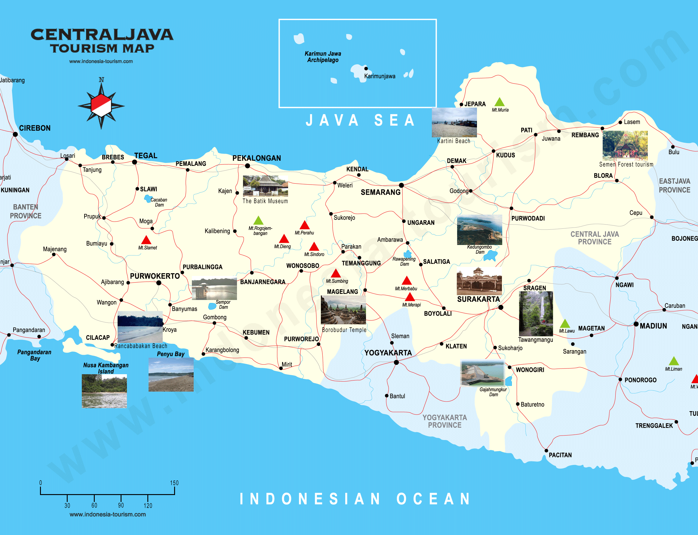
Central Java is a province of Indonesia. It forms the middle portion of the island of Java. The administrative capital is Semarang.
Central Java is also a cultural concept that includes the Special Region and city of Yogyakarta. However, administratively the city and surrounding region has been part of a separate special region since Indonesian independence.
Located in the middle of the island of Java, the Central Java province is bordered by West Java and East Java provinces. A small portion of its south region is the Yogyakarta Special Region province, fully enclosed on the landward side by the Central Java province. To the north and the south, the Central Java province faces the Java Sea and the Indian Ocean. Central Java includes offshore islands such as Karimun Jawa Islands in the north, and Nusakambangan in the southwest. Yogyakarta is historically and culturally part of the Central Java region, although it is now a separate administrative entity.
Central JavaThe geography of Central Java is regular with small strips of lowlands near the northern and southern coast with mountain ranges in the centre of the region. To the west lies an active stratovolcano Mount Slamet, and further east is the Dieng Volcanic Complex on Dieng Plateau. Southeast of Dieng lies the Kedu Plain, which is bordered to the east side by the twin volcanoes of Mount Merapi and Mount Merbabu. South of Semarang, lies Mount Ungaran, and to the north-east of the city lies Mount Muria on the most northern tip of Java. To the east near the border with East Java lies Mount Lawu, where its eastern slopes are in the East Java province.
Due to its active volcanic history, volcanic ash makes Central Java highly fertile agriculture land. Paddy fields are extensive, except in the southeastern Gunung Kidul region partly due to the high concentration of limestone and its location in a rain shadow from the prevailing weather.
The largest rivers are the Serayu in the west, which empties into the Indian Ocean, and the Solo which flows into East Java.
On the eve of the World War II in 1942, Central Java was subdivided into 7 residencies which corresponded more or less with the main regions of this area. These residencies were Banjoemas, Kedoe, Pekalongan, Semarang, and Djapara-Rembang plus the so-called Gouvernement Soerakarta and Gouvernement Jogjakarta. However after the local elections in 1957 the role of these residencies were reduced until they finally disappeared.
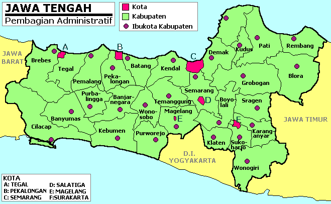
Nowadays Central Java is divided into 29 regencies (kabupaten) and 6 cities (kota, previously kotamadya and kota pradja), the latter being independent of any regency. These contemporary regencies and cities can further be subdivided into 565 districts (kecamatan). These districts are further subdivided into 7,804 rural communes or "villages" (desa) and 764 urban communes (kelurahan).
Java has been inhabited by humans or their ancestors since prehistorical times. In Central Java and the adjacent territories in East Java remains known as "Java Man" were discovered in the 1890s by the Dutch anatomist and geologist Eugxne Dubois. Java Man belongs to the species Homo erectus. They are believed to be about 1.7 millions years old.
Then about 40,000 years ago, Australoid peoples related to modern Australian Aboriginals and Melanesians colonised Central Java. They were assimilated or replaced by Mongoloid Austronesians by about 3000 BC, who brought with them technologies of pottery, outrigger canoes, the bow and arrow, and introduced domesticated pigs, fowls, and dogs. They also introduced cultivated rice and millet.
Recorded history began in Central Java in the 7th century AD. The writing, as well as Hinduism and Buddhism, were brought to Central Java by Indians from South Asia. Central Java was a centre of power in Java back then.
In 664 AD, the Chinese monk Hui-neng visited the Javanese port city he called HÄ"lxng or Ho-ling, where he translated various Buddhist scriptures into Chinese with the assistance of the Javanese Buddhist monk Jxānabhadra. It isn't precisely known what is meant by the name HÄ"lxng. It used to be considered the Chinese transcription of Kalinga but it now most commonly thought of as a rendering of the name Areng. HÄ"lxng is believed to be located somewhere between Semarang and Jepara.
The 1st dated inscription in Central Java is the Inscription of Canggal which is from 732 AD. This inscription which hailed from Kedu, is written in Sanskrit in Pallava script. In this inscription it is written that a Shaivite king named Sri Sanjaya established a kingdom called Mataram. Under the reign of Sanjaya's dynasty several monuments such as the Prambanan temple complex were built.
In the meantime a competing dynasty arose, which adhered to Buddhism. This was the Sailendra dynasty, also from Kedu, which built the Borobudur temple.
After 820 there is no more mention of HÄ"lxng in Chinese records. This fact coincides with the overthrow of the Sailendras by the Sanjayas who restored Shaivism as the dominant religion. Then in the middle of the 10th century, for unknown reason, the centre of power moved to Eastern Java.
A few centuries later, after the destruction of the great Hindu Majapahit Empire in the 15th - 16th centuries by the Central Javanese Muslim kingdom of Demak, the Javanese centre of power moved back to Central Java. In the meanwhile European traders began to frequent Central Javanese ports. The Dutch established a presence in the region through their East India Company.
After Demak itself collapsed, a new kingdom on the Kedu Plain emerged. This new kingdom, which was also a sultanate, bore the old name of Mataram. Under the reign of Sultan Agung, Mataram was able to conquer almost all of Java and beyond by the 17th century, but internal disputes and Dutch intrigues forced Mataram to cede more and more land to the Dutch. These cessions finally led to several partitions of Mataram. The 1st partition was after the 1755 Treaty of Giyanti. This treaty divided the old kingdom in two, the Sultanate of Surakarta and the Sultanate of Yogyakarta. Then few years later Surakarta was divided again with the establishment of the Mangkunegaran after the Treaty of Salatiga.
During the Napoleonic Wars in Europe, Central Java, as part of the Netherlands East-Indies, a Dutch colony, was handed over to the British. In 1813, the Sultanate of Yogyakarta was also divided with the establishment of the Pakualamanan.
After the British left, the Dutch came back, as decided by the Congress of Vienna. Between 1825 - 1830 the Java War ravaged Central Java. The result of the war was a consolidation of the Dutch power. The power and the territories of the divided kingdom of Mataram were greatly reduced.
However Dutch rule brought modernization to Central Java. In the 1900s the modern province of Central Java, the predecessor of the current one was created. It consisted of five regions or gewesten in Dutch. Surakarta and Yogyakarta were autonomous regions called Vorstenlanden. Then after the Indonesian independence the province of Central Java was formalized on August 15, 1950, excluding Yogyakarta but including Surakarta. Since then there have been no (major) changes in the administrative division of Central Java.
In 1998, preluding the downfall of president Suharto, anti Chinese violence broke out in Surakarta and surrounding areas. Much Chinese property and other buildings were burnt down. In 1999, public buildings in Surakarta were burnt again by supporters of Megawati Soekarnoputri after the Indonesia parliament chose Abdurrahman Wahid instead of Soekarnoputri. They carried out 'sweeping actions' against Western foreigners who reside in this city after the September 11, 2001 attacks.
The May 2006 Java earthquake in the south and Yogyakarta devastated many buildings and caused thousands of deaths and more than 37,000 injuries. Today, some areas are still under reconstruction.
As of the 2010 census, Central Java's population stood at some 32,380,687. As of the 1990 census, the population was 28,516,786. So the population has increased approximately 13.5% in 20 years.
The three biggest regencies in terms of population are: Brebes, Banyumas and Cilacap. Together these regencies make up approximately 16% of the Central Javanese population. Major urban population centres are Greater Semarang, Greater Surakarta and the Brebes-Tegal-Slawi area in the north-west of the province.

Related Sites for Central Java

Tuesday, 27 August 2013

Banten, a province of Indonesia

Banten

Banten

Banten is a province of Indonesia. Bordering Jakarta, it is the westernmost province on the island of Java, and its capital is Serang. The population of Banten is projected at 11.75 million people in 2013 at current growth rates, up from over 10.6 million during the 2010 census. Formerly part of the province of West Java, Banten became a separate province in 2000. The province is a transit corridor to Sumatra.
Historically, it has had a culture distinct from the rest of Java and that of the broader Indonesian archipelago. In recent years, however, the northern half, particularly those areas near Jakarta and the Java Sea coast, have experienced rapid rises in population and urbanization, while the southern half, particularly that facing the Indian Ocean, maintains more of its traditional character.
BantenBanten is located near the Sunda Strait’s strategic sea lanes that link Australia and New Zealand to Southeast Asia. Banten’s ports accommodate the excess capacity of sea ports from Jakarta.
Banten is bordered by the Java Sea to the north, the Sunda Strait to the west, and the Indian Ocean to the south. The Special Capital Region of Jakarta and the province of West Java border Banten to the east.
Banten is classified as flat, 186,320 hectares is classified as corrugated with slopes of between 2% and 15% steepness, while the remaining 118,471 hectares (13%) is classified as steep with slopes over 15%.
In the 5th century, Banten was part of the Kingdom of Tarumanagara. The Lebak relic inscriptions, found in lowland villages on the edge of Ci Danghiyang, Munjul, Pandeglang, Banten, were discovered in 1947 and contains 2 lines of poetry with Pallawa script and Sanskrit language. The inscriptions speak of the courage of king Purnawarman. After the collapse of the Tarumanagara kingdom, due to an attack by Srivijaya, power in the western Java fell to the Kingdom of Sunda. The Chinese source, Chu-fan-chi, written circa 1200, Chou Ju-kua mentioned that in the early 13th Century, Srivijaya still ruled Sumatra, the Malay peninsula, and western Java. The source identifies the port of Sunda as strategic and thriving, pepper from Sunda being among the best in quality. The people worked in agriculture and their houses were built on wooden poles (rumah panggung). However, robbers and thieves plagued the country. It was highly possible that the port of Sunda mentioned by Chou Ju-kua was probably refer to the port of Banten.
According to the Portuguese explorer, Tome Pires, in the early 16th century the port of Bantam was an important port within the Kingdom of Sunda along with the ports of Pontang, Cheguide (Cigede), Tangaram (Tangerang), Calapa (Sunda Kelapa) and Chimanuk (estuarine of Cimanuk river).
In 1527, just as the Portuguese fleet was arriving off the coast, newly converted Javanese Muslims under Sunan Gunungjati captured the port of Banten and the surrounding area from the Sundanese leaders and established the Sultanate of Banten. The center of this sultanate, according to J. de Barros, was Banten which was a major port in Southeast Asia rivaling Malacca and Makassar. The city of Banten was located in middle of the bay which is around three miles across. The city was 850 fathoms in length while the seaside town was 400 fathoms in length. Through the middle of town there was a clear river which ships and gale junks could sail into. There is a small tributary of the river extending to the edges of the town. Today, the river isn't so large and only small boats can enter. There was a fortress very near to the town whose walls were made of brick and was seven palms wide. There were wooden defense buildings consisting of two levels and armed with good weapons. The middle of the town square was used for military activities and folk art, and as a market in the morning. The king's palace was located on the southern side of the square. Beside the building was an elevated and flat-roofed, called Srimanganti, which was used by the king when meeting the people. To the west of the square was a great mosque.
In the early 17th century, Banten was an important commercial center on international trade routes in Asia. At the time, the administration and governance of port were very supportive of economic growth. Its territory included the area which is now the province of Lampung in southern Sumatra.
When the Dutch arrived in Indonesia the Portuguese had long been in Banten. The English established a representative site in Banten, a "factory", and were followed by the Dutch. In addition, the French and Danes also came to trade in Banten. In the ensuring competition between the European traders, the Dutch emerged as the winners. The Portuguese fled Banten in after their fleet was destroyed by the Dutch fleet off the coast of Banten.
Banten Province is subdivided into 4 regencies and 4 autonomous cities, listed below with their populations at the 2010 Census.
At the time of the formation of Banten Province, Djamal Hakamudin was appointed as the 1st governor by the Indonesian central government. In 2002, the Banten provincial parliament chose Djoko Munandar and Ratu Atut Chosiyah as governor and deputy governor of Banten respectively. In early 2006, after Djoko Munandar was suspended during an investigation into alleged corruption, Ratu Atut Chosiyah was appointed as acting governor. Finally, on 6 December 2006, a provincial election was held which was won by Ratu Atut Choisiyah as governor and Mohammad Masduki as deputy governor; both served in the period 2007-2011.

Related Sites for Banten

Monday, 24 June 2013

East Java, Province of Indonesia

East Java

East Java

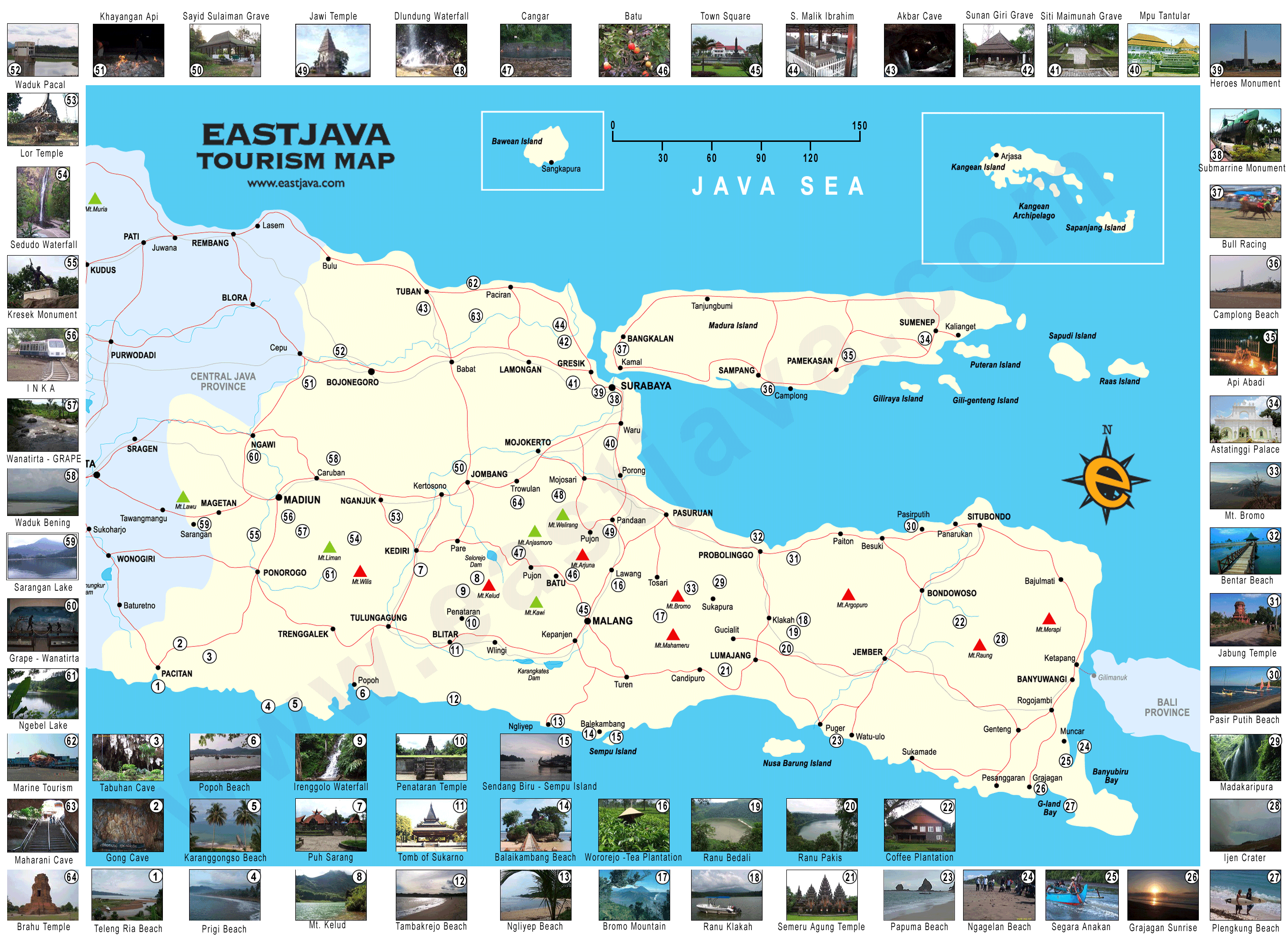
East Java is a province of Indonesia. It is located on the eastern part of the island of Java and includes the neighbouring islands of Madura, and the Kangean, Sapudi, Bawean, and Masalembu groups.
Its capital is Surabaya, the 2nd largest city in Indonesia and a major industrial center and port. It covers an area of 47,922 km2. At the 2010 Census, the province's population was 37,476,000.
It has a land border only with the province of Central Java to the west, being surrounded by sea on all other sides.
East JavaEast Java's history dates back to the famous ancient kingdoms of Kediri and Singosari, which is now a city near Malang. The Majapahit empire, centered at Trowulan, Mojokerto East Java, is celebrated by Indonesians as the golden age of the archipelago. Most of the Eastern Java region was part of the Mataram Kingdom during its peak, apart from the Kingdom of Blambangan at Java's far eastern end nearest to Bali.
East Java is administratively divided into 29 regencies, together with 9 cities (or kotamadya) that are independent of the regency in which they sit.
According to the 2000 census, East Java has 34,765,993 inhabitants, which had increased to 37,476,011 at the 2010 Census, making it the 2nd most populous Indonesian province after West Java. The inhabitants are predominantly ethnically Javanese. Native minorities include migrants from nearby Madura, and distinct Javanese ethnicities such as the Tengger people in Bromo, the Samin and the Osing people in Banyuwangi. East Java also hosts a significant population of other ethnic groups, such as Chinese, Indians, and Arabs. In addition to the national language, Indonesian, they also speak Javanese. Javanese as spoken in the western East Java is a similar dialect to the one spoken in nearby Central Java, with its hierarchy of high, medium, and low registers. In the eastern cities of Surabaya, Malang, and surrounding areas, a more egalitarian version of Javanese is spoken, with less regard for hierarchy and a richer vocabulary for vulgarity.
Hinduism and Buddhism once dominated the island, however Islam, gradually supplanted Hinduism in the 14th and 15th centuries. The last nobles and loyalists of the fallen empire of Majapahit fled from this point to Bali. Islam spread from northern cities in Java where traders from Gujarat, India brought with them Islam. The eastern part of East Java, from Surabaya to Pasuruan, and the cities along the coast, and back to Banyuwangi to Jember, are known as the "horseshoe area" in context with earlier Muslim communities living there.
Pockets of Hinduism
streams of Islam and Hinduism
remain, and syncretic abangan
remain strong.
East Java will build 4
Gresik, Probolinggo and
seaports by 2013 in Lamongan,
Banyuwangi.
Another important form of education that is available in most cities in East Java is the pesantren. This kind of education is built and organized by Islamic clerics, and associated with local or national Muslim organizations. Jombang is a famous city for its pesantren.
East Java supports several regional media outlets. Local newspapers with provincial news reach their readers earlier than their competitors from Jakarta. In the spirit of "providing more news from around readers", most newspapers even issue municipal sections which are different among their distribution areas.
East Java cuisine tends
Central Java.
to be saltier than that of
-

Related Sites for East Java

  • Visit East Java : is The Real Tropical Country of Indonesia Tourism read East Java
  • Visit East Java : is The Real Tropical Country of Indonesia Tourism read East Java
  • Audax East Java read East Java
  • East Java, Indonesia : A Tropical Paradise in The World. Find … read East Java